New NOAA forecast continues to lean above normal for Arizona monsoon rainfall
PHOENIX (AZFamily) — A new forecast from the Climate Prediction Center came out on Thursday, continuing to suggest a wetter-than-normal monsoon season here in Arizona. Last month’s forecast showed a similar wetter trend, and it’s good to see the optimism continuing with this new update.
Here is the updated precipitation forecast, which shows the forecast chances relative to normal. The green colors show where the CPC is leaning toward an above-normal rainfall forecast. Notice green colors are covering all of Arizona!

But before we get too excited, some context is needed to interpret this forecast. The darker shade of green in northeast Arizona indicates a 40-50% chance of above-normal precipitation for July through September (monsoon season).
The lighter shade of green, which covers most of Arizona including the Valley, indicates a 33-40% chance of above-normal precipitation. This might bring up the following question: How can you say the forecast leans above normal when there is less than a 50% chance of it occurring?
To answer this question, it’s easier to look at the “pie chart” version of the same forecast. Here is the same forecast that focuses on the city of Phoenix. Focus on the pie chart in the bottom left corner of the graphic below.
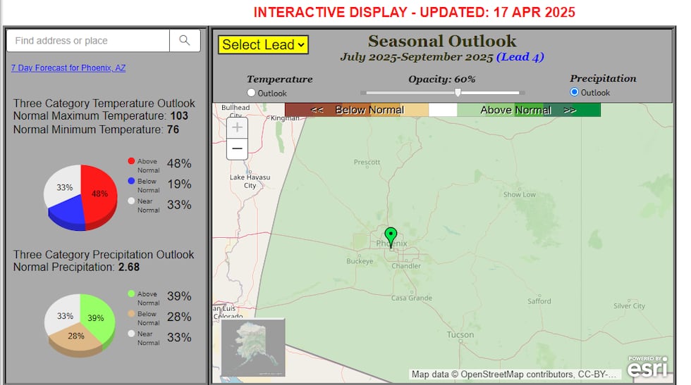
The pie chart forecast shows a 39% chance of above-normal precipitation, a 33% chance of near-normal precipitation, and a 28% chance of below-normal precipitation. In other words, the chance of any scenario happening is low, but the best chance of all those low chances is above-normal precipitation.
Why does the forecast lean above normal for rainfall? One reason is the very dry soil moisture in the southwest. Studies have shown that especially low soil moisture can lead to a more active monsoon.
In the graphic below, the orange shades show where soil moisture is drier than normal. Note all of the orange covering the southwest including Arizona!
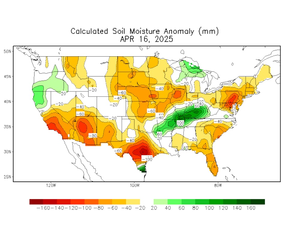
Why would dry soil trend towards a more active monsoon? The reasons are complex, but dry land heats up faster than wetland. More heat rising from the dry soil in the southwest seems to lead to more moisture transport from the eastern Pacific Ocean and the Gulf of California.
As we always say, none of this is set in stone so please check back for updates!
See a spelling or grammatical error in our story? Please click here to report it.
Do you have a photo or video of a breaking news story? Send it to us here with a brief description.
Copyright 2025 KTVK/KPHO. All rights reserved.